Drake's Tan
Superstar
And Jameis Winston is the next Byron LeftwichIn the reality OP hails from Josh Dobbs is winning the Heisman tonight
Jameis Winston = Byron Leftwich

And Jameis Winston is the next Byron LeftwichIn the reality OP hails from Josh Dobbs is winning the Heisman tonight
that map was always a guesstimate, it was never fully accurate. Forexample Africa is three times bigger actually depicted and is infact the biggest continetThere are different kind of maps
There are four basic characteristics of a map that are distorted to some degree, depending on the map projection used. These characteristics include distance, direction, shape, and area.

Commonly, a map projection is a systematic transformation of the latitudes and longitudes of locations on the surface of a sphere or an ellipsoid into locations on a plane.[1] Map projections are necessary for creating maps. All map projections distort the surface in some fashion. Depending on the purpose of the map, some distortions are acceptable and others are not; therefore, different map projections exist in order to preserve some properties of the sphere-like body at the expense of other properties. There is no limit to the number of possible map projections.[2]:1
Even more generally, projections are the subject of several pure mathematical fields, including differential geometry and projective geometry.
Metric properties of maps

An Albers projection shows areas accurately, but distorts shapes.
Many properties can be measured on the Earth's surface independent of its geography. Some of these properties are:Map projections can be constructed to preserve at least one of these properties, though only in a limited way for most. Each projection preserves or compromises or approximates basic metric properties in different ways. The purpose of the map determines which projection should form the base for the map. Because many purposes exist for maps, many projections have been created to suit those purposes.
Distortion
Tissot's indicatrix

Tissot's Indicatrices on the Mercator projection.
The classical way of showing the distortion inherent in a projection is to use Tissot's indicatrix. Nicolas Tissot described how to construct an ellipse that characterizes the amount and orientation of the components of distortion.[2]:147–149[12]By spacing the ellipses regularly along the meridians and parallels, the network of indicatrices shows how distortion varies across the map.

Breeehs I've been travelling to Australia for daamn near 15 years
Bali which is a island / part of Indonesia ..has always been a hop skip x jump from auatralia
The travel time hasnt changed from australia to new Zealand or pNg either lmao..safe for 10 mins or so
The travel time from La to Australia also hasnt changed by a hour or 2 like your saying jt should have
The Northest tips of Australia on both sides of the country have always been right underneath Indonesia/ Timor.and on the eastern sea board it's next to the Torres strait islands which I believe are between. Australia x pNg
U bugging the f out fam .. relax
You must be from this reality then.
I'll just tell you this. As sure as you are that Australia has always been at this location is how sure I am it hasn't.
In the reality I remember, Australia was always thousands of miles south of Papua New Guinea and Indonesia. It was isolated by itself at the bottom of the globe with only New Zealand to the northeast and Tasmania to the south.
This Australia you're describing is as foreign to me as seeing a traffic light that goes from green to yellow to red from the top to bottom. It is that much of a mindfukk.
Never mind
Looked up 'Mandela Effect'
A 'paranormal consultant' thinks because she isn't the only goober who answered "1980s" (before he was even released from prison) when asked when Nelson Mandela died means we're in the matrix or shifting between realities
VS cognitive science research on the patterns and causes of memory construction and glitches.
Berenstein Bears or Berenstain Bears?
50 states or 52 states?
MacDonald's or McDonald's?
Classified types of memory mistakes or untestable unverifiable tinfoil hat hypotheses.
I was living in Australia for some time, but he is right about Torres strait islands is between mainland Australia and PNG. There were always interactions between islanders from the Torres Straits, and the indigenous inhabitants in that part of Australia. So it was not totally isolated as it seems.
that map was always a guesstimate, it was never fully accurate. Forexample Africa is three times bigger actually depicted and is infact the biggest continet
Believe the earth is a round spinning ball with no proof brehs...
Knew this thread was gonna bring out the weirdos.


The seperation between Australia and Papau New Guinea is now roughly 90 miles.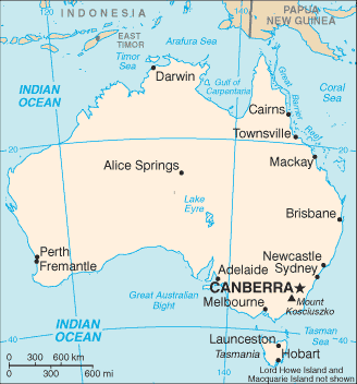
I remember when Australia was surrounded by New Zealand, Tasmania, and thousands of miles of open ocean.
I have no idea where this new Australia that is a stones throw from Papau New Guinea and Indonesia comes from.
This has NOTHING to do with trouble reading maps or not knowing the difficulty in trying to represent a spherical object (like the Earth) on a flat surface (like a map). I've studied enough science and math to know that. My problems with the map in this reality is not my difficulty in understanding how maps are made. My problem is with the reality itself. This is not the world as I remember it. And I'm hoping to find more people who remember the same world I do.

